
Der Ansatz ist eine prototypische Entwicklung einer sogenannten Urbanen Datenplattform. Hier werden Sensordatenströme und 3D-Stadtmodelle verlinkt, um eine raumzeitliche Datenanalyse zu ermöglichen und visuell zu unterstützen.
Das Zentrum für Geodäsie und Geoinformatik (ZGG) bündelt Forschungsaktivitäten, die sich mit der Erfassung und Verarbeitung von räumlicher Information befassen. Sprecher des Zentrums ist Prof. Paul Rawiel.
Die Themenfelder umfassen neben den modernen Entwicklungen in der Vermessung, Photogrammetrie und Fernerkundung einen weiten Bereich, der von Sensortechnik über die informationstechnische Verarbeitung bis hin zu Visualisierungen reicht. Mit der richtigen Auswahl und Kombination verschiedener Sensorprinzipien und Auswertemethoden finden sich neue, innovative Ansätze für Kooperationen in stark interdisziplinären Arbeitsgebieten.
Die Kombinationsmöglichkeiten auf der Sensorseite umfassen optische, mechanische und elektromagnetische Messprinzipien. Zum Einsatz kommen beispielsweise LIDAR Sensoren, die für die baubezogenen Oberflächenerfassung, das mobile Mapping oder auch das autonome Fahren entwickelt wurden. Entsprechende Systeme integrieren oft Kamera-, Laser- und inertiale Messtechnik.
Auf der Analyseseite kommen Technologien zum Einsatz, mit denen entsprechende Systeme wahrnehmen, verstehen, lernen und handeln. Das Maschinelle Lernen ist eine solche Technologie, die neue Innovationen schafft, ohne hierfür neue Programme entwickeln zu müssen. So können zum Beispiel Objekte oder deren Eigenschaften automatisch im Raum zu erkennen und zu bewerten sein.
Als weiteren Ansatz zur Datenauswertung werden Methoden der Geoinformatik entwickelt, um die raumbezogenen Daten zu verarbeiten und in neuen Kontexten bereitzustellen. Schwerpunkte liegen hier auf 3DGeodateninfrastrukturen und geographischen Informationssystemen (GIS).
Themenfelder
Aktuelle Projekte
-
CircularGreenSimCity
zur Seite für mehrDetails
-
Digitaler Zwilling
zur Seite für mehrDetails
-
DigiTwins4PEDs
zur Seite für mehrDetails
-
FORTH-BW
zur Seite für mehrDetails
-
Good Vibrations
zur Seite für mehrDetails
-
HEAL
zur Seite für mehrDetails
-
HFT TransferBot
zur Seite für mehrDetails
-
Hire
zur Seite für mehrDetails
-
iCity 2: DiaOpt4iCity
zur Seite für mehrDetails
-
iCity 2: Mobility4iCity
zur Seite für mehrDetails
-
iCity 2: Managementprojekt
zur Seite für mehrDetails
-
iCity 2: UDigiT4iCity
zur Seite für mehrDetails
-
miraculix
zur Seite für mehrDetails
-
UDigiT-Doctor
zur Seite für mehrDetails
-
SektorSim³
zur Seite für mehrDetails
Abgeschlossene Projekte
-
3DPS-RTGIS
zur Seite für mehrDetails
-
3ProzentPlus
zur Seite für mehrDetails
-
ABOUT
zur Seite für mehrDetails
-
CIGS-Fassade
zur Seite für mehrDetails
-
CityDoctor 2
zur Seite für mehrDetails
-
iCity 1: BIM-konforme Gebäudeerfassung
zur Seite für mehrDetails
-
iCity 1: imaF – Natürliche Lüftung
zur Seite für mehrDetails
-
iCity 1: MUSI
zur Seite für mehrDetails
-
iCity 2: ICT4iCity
zur Seite für mehrDetails
-
iCity 2: IQG4iCity
zur Seite für mehrDetails
-
iCity 2: Streetmoves4iCity
zur Seite für mehrDetails
-
INSPIRER
zur Seite für mehrDetails
-
MobiArch: Stauende-Alarm
zur Seite für mehrDetails
-
Pro.La-Fellbach
zur Seite für mehrDetails
-
SensAR
zur Seite für mehrDetails
-
SIMSTADT
zur Seite für mehrDetails
-
SimStadt 2.0
zur Seite für mehrDetails
-
Smart2Charge
zur Seite für mehrDetails
-
Smart Villages 2
zur Seite für mehrDetails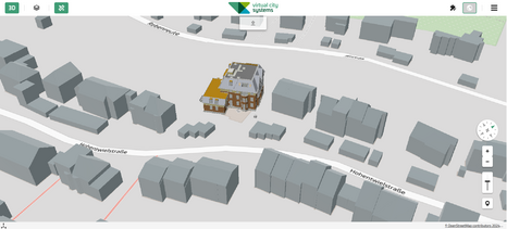
Mitglieder
Professorale Mitglieder
| Name & Position | E-Mail & Telefon | Büro | Kompetenzzentrum | |
|---|---|---|---|---|
 | Professor, Studiendekan Master Vermessung | +49 711 8926 2348 | 2/163 | Geodäsie und Geoinformatik |
 | Geodätisches Landmanagement/Geoinformatik | +49 711 8926 2693 | 2/113 | |
 | Prorektor Forschung und Digitalisierung | +49 711 8926 2663 | 1/121 | Geodäsie und Geoinformatik |
 | Seniorprofessor | +49 711 8926 2610 | 2/210 | Geodäsie und Geoinformatik Industrielle Anwendungen der Informatik und Mathematik |
 | Professor | +49 711 8926 2966 | 2/546 | Geodäsie und Geoinformatik Industrielle Anwendungen der Informatik und MathematikDigitalisierung in Forschung, Lehre & Wirtschaft |
 | Professor | +49 711 8926 2560 | 2/209 | |
 | Professor, Studiendekan Master PG | +49 711 8926 2529 | 2/164 | Geodäsie und Geoinformatik |
 | Seniorprofessor | 2/210 | Geodäsie und Geoinformatik | |
 | Professor | +49 711 8926 2629 | 2/149 |
Mitarbeitende
| Name & Position | E-Mail & Telefon | Büro | Kompetenzzentrum | |
|---|---|---|---|---|
 | Akademischer Mitarbeiter | +49 711 8926 2423 | 2/281 | Geodäsie und Geoinformatik |
 | Akademischer Mitarbeiter | +49 711 8926 2320 | 2/344 | |
| Akademischer Mitarbeiter | +49 711 8926 2732 | 246 | Geodäsie und Geoinformatik | |
 | Akademischer/Forschung Mitarbeiter (GeoInformatic) | +49 711 8926 2838 | 2/281 | Geodäsie und Geoinformatik |
 | Akademische Mitarbeiterin | +49 711 8926 2723 | 2/246 | Geodäsie und Geoinformatik Industrielle Anwendungen der Informatik und Mathematik |
 | Akademischer Mitarbeiter | +49 711 8926 2549 | 2/281 | |
 | Akademische Mitarbeiter / Doktorand | +49 711 8926 2704 | 5/0.61 | Digitalisierung in Forschung, Lehre & Wirtschaft Geodäsie und GeoinformatikIntegrale ArchitekturNachhaltige StadtentwicklungNeue Forschungsfelder |